
Portal:Geography

The Geography Portal

Geography (from Greek: γεωγραφία, geographia, literally "earth description") is a field of science devoted to the study of the lands, features, inhabitants, and phenomena of the Earth and planets. The first person to use the word γεωγραφία was Eratosthenes (276–194 BC). Geography is an all-encompassing discipline that seeks an understanding of Earth and its human and natural complexities—not merely where objects are, but also how they have changed and come to be.
Geography is often defined in terms of two branches: human geography and physical geography. Human geography deals with the study of people and their communities, cultures, economies, and interactions with the environment by studying their relations with and across space and place. Physical geography deals with the study of processes and patterns in the natural environment like the atmosphere, hydrosphere, biosphere, and geosphere.
Vital article

Did you know...
- ... that during the collision of India with Asia, the southern part of the Tibetan Plateau achieved its high elevation before the northern part?
- ... that the dark and fatalistic humour of Canadian comedians has been attributed to the dangers of Canada's climate and geography?
- ... that the first known paravian dinosaurs were from China, but they now live on every continent?
Get involved

Places around you
Featured article
Antarctica (/ænˈtɑːrtɪkə/ or /æntˈɑːrktɪkə/ (

 listen)) is Earth's southernmost continent. It contains the geographic South Pole and is situated in the Antarctic region of the Southern Hemisphere, almost entirely south of the Antarctic Circle, and is surrounded by the Southern Ocean. At 14,200,000 square kilometres (5,500,000 square miles), it is the fifth-largest continent and nearly twice the size of Australia. At 0.00008 people per square kilometre, it is by far the least densely populated continent. About 98% of Antarctica is covered by ice that averages 1.9 km (1.2 mi; 6,200 ft) in thickness, which extends to all but the northernmost reaches of the Antarctic Peninsula. Read more...
Top 10 WikiProject Geography Popular articles of the month

This article documents countries and territories affected by and responses to the coronavirus responsible for the 2019–20 pandemic first detected in Wuhan, Hubei, China. It may not include all the contemporary major responses and measures.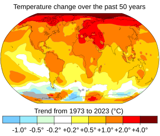 Average global temperatures from 2010 to 2019 compared to a baseline average from 1951 to 1978. Source: NASA.
Global warming is the long-term rise in the average temperature of the Earth's climate system. It is a major aspect of climate change and has been demonstrated by direct temperature measurements and by measurements of various effects of the warming. Global warming and climate change are often used interchangeably. But, more accurately, global warming is the mainly human-caused increase in global surface temperatures and its projected continuation, while climate change includes both global warming and its effects, such as changes in precipitation. While there have been prehistoric periods of global warming, observed changes since the mid-20th century have been unprecedented in rate and scale.- Millennials, also known as Generation Y (or simply Gen Y), are the demographic cohort following Generation X and preceding Generation Z. Researchers and popular media use the early 1980s as starting birth years and the mid-1990s to early 2000s as ending birth years, with 1981 to 1996 a widely accepted defining range for the generation.
The United States of America is a federal republic consisting of 50 states, a federal district (Washington, D.C., the capital city of the United States), five major territories, and various minor islands. The 48 contiguous states and Washington, D.C., are in North America between Canada and Mexico, while Alaska is in the far northwestern part of North America and Hawaii is an archipelago in the mid-Pacific. Territories of the United States are scattered throughout the Pacific Ocean and the Caribbean Sea.- Generation Z (or Gen Z for short) is the demographic cohort succeeding Millennials and preceding Generation Alpha. Researchers and popular media use the mid- to late-1990s as starting birth years and the early 2010s as ending birth years. Members of Generation Z have used digital technology since a young age and are comfortable with the Internet and social media, but are not necessarily digitally literate. Most members of Generation Z are the children of Generation X.
- Determining the largest cities in the world depends on which definitions of city are used, as well as the criteria used for size: this article focuses on population. The United Nations uses three definitions for what constitutes a city, as not all cities may be classified using the same criteria. Cities may be defined as the cities proper, the extent of their urban area, or their metropolitan regions.
California is a state in the Pacific Region of the United States. With 39.5 million residents across a total area of about 163,696 square miles (423,970 km2), California is the most populous U.S. state and the third-largest by area. The state capital is Sacramento. The Greater Los Angeles Area and the San Francisco Bay Area are the nation's second- and fifth-most populous urban regions, with 18.7 million and 9.7 million residents respectively. Los Angeles is California's most populous city, and the country's second-most populous, after New York City. California also has the nation's most populous county, Los Angeles County, and its largest county by area, San Bernardino County. The City and County of San Francisco is both the country's second most densely populated major city after New York City and the fifth most densely populated county, behind only four of the five New York City boroughs.
Hong Kong (/ˌhɒŋˈkɒŋ/ (listen); Chinese: 香港, Cantonese: [hœ́ːŋ.kɔ̌ːŋ] (listen)), officially the Hong Kong Special Administrative Region of the People's Republic of China (HKSAR), is a city and special administrative region of China in the eastern Pearl River Delta by the South China Sea. With over 7.4 million people of various nationalities in a 1,104-square-kilometre (426 sq mi) territory, Hong Kong is one of the most densely populated places in the world.
Earth is the third planet from the Sun and the only astronomical object known to harbor life. According to radiometric dating and other evidence, Earth formed over 4.5 billion years ago. Earth's gravity interacts with other objects in space, especially the Sun and the Moon, which is Earth's only natural satellite. Earth orbits around the Sun in 365.256 days, a period known as an Earth sidereal year. During this time, Earth rotates about its axis about 365.256 times.
Washington, D.C., (/ˈwɑːʃɪŋtən ˌdiːˈsiː/) formally the District of Columbia and commonly referred to as D.C., Washington, or The District, is the capital of the United States. Founded after the American Revolution as the seat of government of the newly independent country, Washington was named after George Washington, the first president of the United States and a Founding Father. As the seat of the United States federal government and several international organizations, Washington is an important world political capital. The city, located on the Potomac River bordering Maryland and Virginia, is one of the most visited cities in the world, with more than 20 million tourists annually.


Categories

Featured pictures


Main articles
| Branches |
| ||||||
|---|---|---|---|---|---|---|---|
| Techniques and tools | |||||||
| Institutions | |||||||
| Education | |||||||


Related portals


Associated Wikimedia


