Category:Maps
Jump to navigation
Jump to search
 The article Maps on Wikipedia projects:

- (en) Map
- (an) Mapa
- (ar) خريطة
- (ast) Mapa
- (bg) Карта
- (bn) মানচিত্র
- (bs) Karta
- (ca) Plànol
- (cs) Mapa
- (cy) Map
- (da) Kort (geografi)
- (de) Karte (Kartografie)
- (eo) Mapo
- (es) Mapa
- (et) Kaart (kartograafia)
- (fa) نقشه (زمین)
- (fi) Kartta
- (fr) Carte géographique
- (gan) 地圖
- (gl) Mapa
- (he) מפה
- (hi) मानचित्र
- (hr) Karta
- (hu) Térkép
- (id) Peta
- (is) Kort
- (it) Mappa
- (ja) 地図
- (ka) გეოგრაფიული რუკა
- (ko) 지도
- (la) Tabula geographica
- (lb) Landkaart
- (lt) Žemėlapis
- (ml) ഭൂപടം
- (ms) Peta
- (nl) Kaart (cartografie)
- (nn) Kart
- (no) Kart
- (oc) Mapa
- (pl) Mapa
- (pt) Mapa
- (ro) Hartă
- (ru) Географическая карта
- (sa) Хаарта
- (sco) Cairt
- (si) ple:Map
- (sk) Mapa
- (sl) Zemljevid
- (sq) Harta
- (sr) Карта (мапа)
- (su) Atlas
- (sv) Karta
- (sw) Ramani
- (ta) நிலப்படம்
- (tg) Харита
- (th) แผนที่
- (tl) Mapa
- (tr) Harita
- (uk) Географічна карта
- (vi) Bản đồ
- (yi) מאפע
- (zh) 地图
- (zh-classical) 地圖
- (zh-yue) 地圖
Before changing or adding maps, please read the brief guideline on the organizational schema About this Category developed during an eight month effort by a working group in 2007–2008.
- See also maps needing categories in Category:Unidentified maps
- See also these related categories: (These categories may contain more maps. Please categorize them in map categories.)
- Category:Cartography – for map symbols, projections, etc.
- Category:Demography
- Category:Geography
- Category:Aerial photographs
- Category:Satellite pictures
- Category:Astronomical maps – maps and star charts
- Category:Cartographic reliefs for models of landscape profiles
Resources:
visual representation of a geographical area  | |||
| Upload media | |||
| Instance of | type of map | ||
|---|---|---|---|
| Subclass of | map, cartographic work, cartographic material | ||
| Part of | Map series | ||
| |||
Subcategories
This category has the following 35 subcategories, out of 35 total.
!
*
?
A
B
C
D
E
F
I
M
N
O
P
S
Media in category "Maps"
The following 200 files are in this category, out of 3,071 total.
(previous page) (next page)_2014-04-25_22-00.png/120px-(added_South_Korea)_2014-04-25_22-00.png) (added South Korea) 2014-04-25 22-00.png 786 × 317; 17 KB
(added South Korea) 2014-04-25 22-00.png 786 × 317; 17 KB
.jpg/120px-(Arabic-map).jpg) (Arabic-map).jpg 3,508 × 2,480; 1.53 MB
(Arabic-map).jpg 3,508 × 2,480; 1.53 MB
.jpg/120px-(English-map).jpg) (English-map).jpg 3,508 × 2,480; 1.56 MB
(English-map).jpg 3,508 × 2,480; 1.56 MB
_-_Manonville_(ban_communal).png/120px-(Fig_1)_-_Manonville_(ban_communal).png) (Fig 1) - Manonville (ban communal).png 3,507 × 2,480; 3.23 MB
(Fig 1) - Manonville (ban communal).png 3,507 × 2,480; 3.23 MB
.jpg/120px-..._map_of_Harishchandragad_(6841471361).jpg) ... map of Harishchandragad (6841471361).jpg 4,000 × 2,672; 4.33 MB
... map of Harishchandragad (6841471361).jpg 4,000 × 2,672; 4.33 MB
 08-kobelyackiy.jpg 1,589 × 2,000; 656 KB
 11. Map.jpg 2,831 × 2,331; 3.14 MB
 1508 voyage.png 1,971 × 2,077; 366 KB
.jpg/120px-16_of_%27The_Handbook_to_the_City_of_Norwich%2C_etc%27_(11162030484).jpg) 16 of 'The Handbook to the City of Norwich, etc' (11162030484).jpg 2,485 × 2,108; 1.13 MB
16 of 'The Handbook to the City of Norwich, etc' (11162030484).jpg 2,485 × 2,108; 1.13 MB
 185346-004-E7ED4DDA.jpg 670 × 450; 187 KB
 1856 р. Луї-Етьєн Дюсьє Фрагмент.png 1,110 × 608; 1.14 MB
 1877 р. Фрагмент карти 843 р.png 999 × 494; 1,002 KB
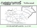 1909 Map of Malabar.jpg 2,560 × 1,920; 587 KB
 1917-1923 Revolutions.png 2,000 × 2,027; 441 KB
 1918 Împărțirea administrativă a Republicii Democratice Moldovenești în 1917.jpg 1,180 × 1,253; 355 KB
 19th century map of Sundridge with Ide Hill.jpg 424 × 477; 84 KB
 1p copy--.png 1,905 × 1,376; 5.68 MB
 1stMithritadicwar89BC.svg 512 × 404; 771 KB
 2 Molotkow źródlo soli.png 536 × 286; 230 KB
 2-A.gif 1,417 × 1,115; 889 KB
 2008specelectsen.png 820 × 630; 22 KB
 2013 elections.png 1,425 × 625; 16 KB
 20130421131537!Slavic languages.png 675 × 622; 34 KB
 2014 elections.png 1,425 × 625; 18 KB
 2016 07 15 AFC Tiko Kamerun 2.PNG 1,360 × 768; 901 KB
 2016 07 15 Tiko Kamerun AFC.jpg 1,360 × 768; 98 KB
.jpg/120px-2016_Climate_Trends_Continue_to_Break_Records_(28381930286).jpg) 2016 Climate Trends Continue to Break Records (28381930286).jpg 1,920 × 1,080; 126 KB
2016 Climate Trends Continue to Break Records (28381930286).jpg 1,920 × 1,080; 126 KB
 2017九寨沟地震主震位置.png 1,370 × 1,182; 456 KB
 2018 AWS Sites ALL 03 29 2018.jpg 3,300 × 2,550; 1.66 MB
 2019 10 7 KZ Ravensbrück mit Siemenslager.JPG 1,175 × 605; 97 KB
 2019 1023 USNG ELM Projects.jpg 1,195 × 1,130; 190 KB
 2020 Tennessee Tornadoes Location Map.jpg 983 × 488; 166 KB
 20200112131802!Ачхой-Мартановское.svg 1,948 × 3,154; 2.96 MB
 2050 dünya.png 1,419 × 1,095; 109 KB
 20th Century map of Friston.png 609 × 379; 572 KB
 20th Century map of Ringshall, Suffolk.png 651 × 326; 411 KB
 22303-G-A-Moray-The-State-of-Matrimony-1909.jpg 800 × 1,357; 313 KB
 3-overview-of-global-alcohol-trade.png 774 × 744; 205 KB
 3007 Balti szláv országok.png 930 × 749; 169 KB
 38th Infantry and Task Force Zebra positions, 16 May 1951.jpg 729 × 581; 130 KB
 41118 2018 47 Fig12 HTML.png.webp 1,362 × 973; 228 KB
 41118 2018 47 Fig13 HTML.png.webp 1,362 × 973; 224 KB
 41118 2018 47 Fig3 HTML.png.webp 1,362 × 1,014; 146 KB
 47 1920x0 35f.jpg 989 × 622; 188 KB
.jpg/94px-50233.BA--Newton%2C_NJ--Property_issues_(2f1d569d-f0a6-4e2d-ab1b-db2574a65a99).jpg) 50233.BA--Newton, NJ--Property issues (2f1d569d-f0a6-4e2d-ab1b-db2574a65a99).jpg 1,613 × 2,058; 1.24 MB
50233.BA--Newton, NJ--Property issues (2f1d569d-f0a6-4e2d-ab1b-db2574a65a99).jpg 1,613 × 2,058; 1.24 MB
.jpg/56px-50233.BA--Newton%2C_NJ--Property_issues_(3aef6ca0-f0a4-4921-b252-c73d7d085cf2).jpg) 50233.BA--Newton, NJ--Property issues (3aef6ca0-f0a4-4921-b252-c73d7d085cf2).jpg 650 × 1,381; 263 KB
50233.BA--Newton, NJ--Property issues (3aef6ca0-f0a4-4921-b252-c73d7d085cf2).jpg 650 × 1,381; 263 KB
 5day track 17E 2006.gif 895 × 716; 21 KB
 5day track 18E 2006.gif 895 × 716; 17 KB
 5day track 21E 2006.gif 895 × 716; 18 KB
 8 mataredonda.jpg 3,481 × 2,594; 1.55 MB
.jpg/120px-8_of_%27De_onafhankelijke_Congostaat._Met_eene_kaart_en_34_lichtteekeningen%27_(11250731263).jpg) 8 of 'De onafhankelijke Congostaat. Met eene kaart en 34 lichtteekeningen' (11250731263).jpg 2,995 × 2,513; 1.24 MB
8 of 'De onafhankelijke Congostaat. Met eene kaart en 34 lichtteekeningen' (11250731263).jpg 2,995 × 2,513; 1.24 MB
 800-c-Reg4-B-1836b.jpg 6,958 × 5,582; 8.37 MB
 9-0f11e15c1e.jpg 638 × 373; 102 KB
 A 20th Century map of Lower Hardres.png 473 × 683; 724 KB
)_(20049117804).jpg/120px-A_complete_guide_to_the_English_lakes_(186-%3F))_(20049117804).jpg) A complete guide to the English lakes (186-?)) (20049117804).jpg 2,400 × 1,465; 1.11 MB
A complete guide to the English lakes (186-?)) (20049117804).jpg 2,400 × 1,465; 1.11 MB
)_(20049126214).jpg/120px-A_complete_guide_to_the_English_lakes_(186-%3F))_(20049126214).jpg) A complete guide to the English lakes (186-?)) (20049126214).jpg 2,400 × 1,471; 1.07 MB
A complete guide to the English lakes (186-?)) (20049126214).jpg 2,400 × 1,471; 1.07 MB
)_(20484934889).jpg/120px-A_complete_guide_to_the_English_lakes_(186-%3F))_(20484934889).jpg) A complete guide to the English lakes (186-?)) (20484934889).jpg 2,032 × 1,442; 632 KB
A complete guide to the English lakes (186-?)) (20484934889).jpg 2,032 × 1,442; 632 KB
)_(20662458482).jpg/120px-A_complete_guide_to_the_English_lakes_(186-%3F))_(20662458482).jpg) A complete guide to the English lakes (186-?)) (20662458482).jpg 2,208 × 1,399; 714 KB
A complete guide to the English lakes (186-?)) (20662458482).jpg 2,208 × 1,399; 714 KB
)_(20678406821).jpg/120px-A_complete_guide_to_the_English_lakes_(186-%3F))_(20678406821).jpg) A complete guide to the English lakes (186-?)) (20678406821).jpg 2,400 × 1,434; 820 KB
A complete guide to the English lakes (186-?)) (20678406821).jpg 2,400 × 1,434; 820 KB
 A group of noble dames--map of Wessex.png 3,063 × 1,965; 191 KB
 A New Description of Carolina.jpg 1,960 × 1,500; 3.05 MB
 A Short History of Wales - Section from Holyhead to Cardiff.jpg 2,550 × 1,178; 143 KB
 A'Aman Map.jpg 3,024 × 4,032; 7.92 MB
 A-MUSLIM-POPULATION-PENETRATION-640x468.jpg 640 × 468; 62 KB
 Aa and connecting waterways.jpg 500 × 556; 167 KB
 AAK parti regjionale.jpg 3,507 × 2,480; 428 KB
 Abacela relative to Spain.png 342 × 170; 38 KB
 Abacela within Oregon.png 218 × 268; 49 KB
 Ablanitsa Lovech Map with pushpin.png 246 × 158; 89 KB
 Aboncourt.png 2,339 × 1,654; 1.34 MB
 Access Business Park Map.jpg 1,700 × 2,200; 1.19 MB
 AchkarrenTopographie.jpg 300 × 300; 34 KB
 Acta Eruditorum - VII mappe arabia mesopotamia, 1692 – BEIC 13352531.jpg 1,653 × 1,901; 239 KB
 Activos IEnova 2019.png 793 × 595; 305 KB
 Adja-to map.jpg 3,639 × 3,118; 355 KB
 Admin-St-Vinc.JPG 295 × 530; 11 KB
 Admin10.gif 2,688 × 1,997; 294 KB
 Administration map of Dien Ban Town, Quang Nam Province.jpg 2,481 × 3,509; 5.11 MB
 Adria destinations.png 1,405 × 601; 99 KB
 Adroit's Collaborations.jpg 2,333 × 950; 813 KB
 Adventure 10feb1922-- Forced Luck--map.png 482 × 326; 16 KB
 AECR map 2018-09-11.png 1,532 × 1,162; 178 KB
 AFC Asian Cup Champions.PNG 668 × 468; 16 KB
 Africa origin thesis for L3 Fig4 HTML.jpg 659 × 370; 55 KB
 After1865.png 884 × 884; 824 KB
 Agen - Limoges.png 896 × 656; 1.56 MB
 AH Basic Countries 2013.png 2,000 × 1,529; 369 KB
 Ahmedabad Heritage Walk Route.jpg 521 × 537; 49 KB
 Aip-vfr-karte.jpg 2,448 × 3,264; 1.24 MB
 Aituà el 1812.png 301 × 369; 185 KB
 Alban-map.png 1,589 × 1,125; 1.46 MB
 Albanian States.svg 699 × 522; 54 KB
 All Gender Mandates by region.svg 512 × 288; 123 KB
 Allain.png 3,507 × 2,480; 3.41 MB
 Allamps.png 2,339 × 1,653; 1.91 MB
 Alley First map, Varna, Bulgaria.png 1,254 × 654; 288 KB
 Alto rio pardo.gif 300 × 358; 26 KB
 Amasya2014Yerel.png 683 × 541; 34 KB
 AmazonSiteAvailability2019.svg 512 × 263; 817 KB
 Amer-sports-worldwide-7005953FC4EDFF5.jpg 700 × 514; 72 KB
 Americasflagmap.png 2,000 × 2,016; 530 KB
.jpg/120px-Amir_Timur%27s_resume_-_cities_he_conquered_(9330886107).jpg) Amir Timur's resume - cities he conquered (9330886107).jpg 3,446 × 2,201; 1.47 MB
Amir Timur's resume - cities he conquered (9330886107).jpg 3,446 × 2,201; 1.47 MB
 Amur Labour Soviet Republic.jpg 625 × 497; 33 KB
 Anamas Yöresi.png 852 × 589; 161 KB
 Ancash Santa.PNG 300 × 400; 4 KB
 Ancians arrondiments d'Alèir.PNG 147 × 111; 13 KB
 Ancians arrondiments deis Aups d'Auta Provença.PNG 220 × 215; 41 KB
 Ancians arrondiments deis Auts Aups.PNG 250 × 206; 44 KB
 Anciennes EPCI qui ont fusionné en CC Porte de DrômArdèche.jpg 600 × 378; 38 KB
 Ancient City of Polonnaruwa පොලොන්නරුව.jpg 950 × 1,718; 174 KB
 Ancient Nara.jpg 2,098 × 1,698; 621 KB
 Andaman nicobar 7.jpg 388 × 898; 79 KB
 Ansauville.png 3,507 × 2,480; 2.94 MB
 Ansicht und Plan von Bad Soden am Taunus und dem dortigen Salzbergwerk, 1605.jpg 6,904 × 4,912; 2.49 MB
 Ansicht von Schloss und Stadt Homburg vor der Höhe, um 1640.jpg 4,787 × 6,315; 2.81 MB
 Anta e Guetim em Espinho.png 655 × 761; 39 KB
 Antalya2004Yerel.png 786 × 426; 30 KB
 Antioch Alexandria and Seleucia.png 589 × 349; 540 KB
 Anuradhapura ancient city අනුරාදපුර.jpg 1,500 × 1,558; 266 KB
 Anzeigenblattgruppe Südbayern Karte.png 933 × 879; 167 KB
 Análise dos contrastes cartográficos em Google Maps e OpenStreetMap.png 1,057 × 793; 360 KB
 Approximate borders of historical Karelia.jpg 351 × 670; 271 KB
 Approximate route of Sarah Kemble Knight's Journey, 1704-1705.png 1,100 × 788; 1.65 MB
 Arab World Green 2.png 800 × 406; 71 KB
.png/111px-Arapaho_and_Cheyenne_1851_treaty_territory._(Area_426_and_477).png) Arapaho and Cheyenne 1851 treaty territory. (Area 426 and 477).png 1,664 × 1,803; 6.07 MB
Arapaho and Cheyenne 1851 treaty territory. (Area 426 and 477).png 1,664 × 1,803; 6.07 MB
 Araucaniablanca.jpg 400 × 387; 24 KB
.jpg/77px-Arbeitslager_Workuta_(Lageskizze).jpg) Arbeitslager Workuta (Lageskizze).jpg 1,662 × 2,568; 900 KB
Arbeitslager Workuta (Lageskizze).jpg 1,662 × 2,568; 900 KB
 Archaeological Sites Swat Valley.jpg 2,500 × 1,497; 638 KB
 Archidiócesis de Bangui.png 600 × 410; 43 KB
 Arcidiocesi di Manfredonia - Vieste.png 2,091 × 2,894; 208 KB
 Arcidiocesi di Otranto.png 1,382 × 1,477; 130 KB
 Arcidiocesi di Trani - Barletta - Bisceglie.png 1,986 × 1,769; 153 KB
 Arciechow.map.png 213 × 164; 7 KB
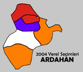 Ardahan2004Yerel.png 588 × 516; 24 KB
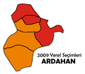 Ardahan2009Yerel.png 588 × 516; 24 KB
 AreaTraffic control system.jpg 1,256 × 726; 411 KB
 Arena river drainage basin.png 588 × 653; 72 KB
 Arikara Villages, 1823-1886, PNG file.png 1,076 × 863; 1,022 KB
 ARKO.jpg 712 × 696; 120 KB
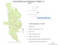
 Arlington Heights-Demograhics.svg 990 × 763; 838 KB
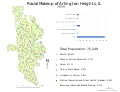
 ArlingtonHeights Demographic.svg 990 × 763; 838 KB
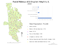
 ArlingtonHeights Demographics2018.svg 990 × 763; 838 KB
 ArlingtonHeights-Demographics2018.svg 990 × 763; 873 KB
 ArlingtonHeights.svg 990 × 763; 838 KB
 ArlingtonHeightsDem2018.svg 990 × 763; 873 KB
 ArlingtonHeightsDemographics 2018.svg 990 × 763; 838 KB
 Armenia Artsakh topographic map-blank.svg 757 × 502; 2.81 MB
 Armenia Map.png 362 × 558; 56 KB
 Armenia Niderland Locator.png 1,984 × 1,736; 93 KB
 Armenian 1-st elect. district.png 684 × 660; 25 KB
 Artsakh province.jpg 946 × 817; 129 KB
 Artvin2004Yerel.png 762 × 580; 33 KB
 Arwal.png 101 × 120; 13 KB
 Asi, Orontes River.png 301 × 840; 365 KB
 Asia Parliamentary Assembly.png 1,357 × 628; 47 KB
 Asia-Luenga abjasia.JPG 250 × 115; 6 KB
 Asia-Pacific Group Member States.svg 512 × 227; 752 KB
.png/120px-Asian_Development_Bank_(DMC_Stages).png) Asian Development Bank (DMC Stages).png 1,357 × 628; 48 KB
Asian Development Bank (DMC Stages).png 1,357 × 628; 48 KB
.png/120px-Assiniboine_1851_treaty_territory._(Area_300).png) Assiniboine 1851 treaty territory. (Area 300).png 824 × 761; 1.18 MB
Assiniboine 1851 treaty territory. (Area 300).png 824 × 761; 1.18 MB
 ATAroa-2891-2017-11-03.png 4,000 × 2,500; 187 KB
 Atavakan lur.png 1,500 × 900; 380 KB
 Atlante Topografico dello Stato di Milano, Carta generale, Tavola A1.jpg 4,608 × 6,144; 3.59 MB
 Atlante Topografico dello Stato di Milano, Carta generale, Tavola A2.jpg 2,304 × 3,072; 1.73 MB
 Atlantic puffin range.svg 1,200 × 580; 664 KB
 Atlantic puffin range4.jpg 320 × 128; 14 KB
 Atlas Ch’onhado - Expo Le Monde vu d'Asie au Musée Guimet.jpg 2,584 × 2,352; 1.37 MB
 Atlas historyczny RP.jpg 4,109 × 3,330; 19.03 MB
 Aureliaplan.jpg 656 × 445; 80 KB
 Aurseulles a.png 2,000 × 1,290; 500 KB
 Auschwitz camps.png 872 × 490; 441 KB
 Ausschnitt Winom aus Visscher 1622.jpg 364 × 296; 88 KB
..jpg/96px-Austla_küla_lapimaad_J.Thomsoni_kaart_1928_(1855)..jpg) Austla küla lapimaad J.Thomsoni kaart 1928 (1855)..jpg 1,800 × 2,259; 475 KB
Austla küla lapimaad J.Thomsoni kaart 1928 (1855)..jpg 1,800 × 2,259; 475 KB
.jpg)
.jpg)
_-_Manonville_(ban_communal).png)
.jpg)

%27_(11109994645).jpg)


.jpg)
_from_various_authorities._(Supplement.)%27_(11191625713).jpg)
.jpg)
.jpg)
%27_(11242844926).jpg)


.jpg)


.jpg)


.jpg)


)%27_(11005444544).jpg)
.jpg)


.jpg)
.jpg)
.jpg)
.jpg)
.jpg)
.jpg)
.jpg)
.jpg)
.jpg)
.jpg)


.jpg)


)_(20049117804).jpg)
)_(20049126214).jpg)
)_(20484934889).jpg)
)_(20662458482).jpg)
)_(20678406821).jpg)


.jpg)
.jpg)
.jpg)
.jpg)
.jpg)


.jpg)

.jpg)
.jpg)


.pdf/page1-120px-Antietam_maps_of_different_phases_of_battle_on_Sept._17%2C_1862_(83a89d2f-fba1-40bc-a9b3-568b80f79b2c).pdf.jpg)


.png)

.jpg)


.png)


.png)
.png)


..jpg)
_2014-04-25_22-00.png)